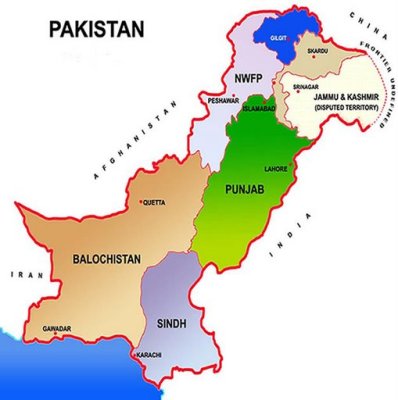
 All about PakistanPage 4Pakistan's Official Map
Drawn by Mian Mahmood Alam Suhrawardy (1920-1999)
National Flower Jasmine
National Tree Deodar (Cedrus Deodara)
National Animal Markhor
National Bird Chakor (Red-legged partridge)
Flora (Plants/Flowers) Pine, Oak, Poplar, Deodar, Maple, Mulberry
Fauna (Animals)
The Pheasant, Leopard, Deer, Ibex, Chinkara, Black buck, Neelgai, Markhor, Marco-Polo sheep, Green turtles, River & Sea fish, Crocodile, Waterfowls
Popular games Cricket, Hockey, Football & Squash.
Tourist's resorts Murree, Quetta, Hunza, Ziarat, Swat, Kaghan, Chitral and Gilgit.
Archaeological sites Moenjo Daro, Harappa, Taxila, Kot Diji, Mehr Garh, Takht Bhai.
Major Cities Islamabad, Karachi, Lahore, Peshawar, Quetta, Rawalpindi, Hyderabad, Faisalabad, Multan and Sialkot.
Major Crops Cotton, Wheat, Rice and Sugarcane
Agricultural Growth Rate 4.15% in 2002-03
Total cropped area 22.0 million hectares
Industry
Textiles, Cement, Fertilizer, Steel, Sugar, Electric Goods, Shipbuilding
Energy
Major sources: Electricity (Hydel, Thermal, Nuclear) Oil, Coal, and Liquid Petroleum Gas.
Power Generating Capacity 18,062 MW
Health
Hospitals 947
Dispensaries 4,800
Basic Health Units (BHUs) 4,820
Maternity & Child Health Centres 1,084
Rural Health Centres (RHCs) 581
Tuberculosis (TB) Centres 357
Hospital Beds 82,844
Doctors (registered) 101,635
Dentists (registered) 5,068
Nurses (registered 44,520
Paramedics 22,714
Lady Health Workers 6,397
Education
Primary Schools 164,200
Middle Schools 19,100
High Schools 12,900
Arts & Science Colleges 925
Professional Colleges 374
Universities Public Sector (including one WomenUniversity) 29
Private Sector 10
Page 5Home